


LP McKay
/
KSJD
A Cortez nonprofit is reshaping disability services by centering lived experience, employment and community inclusion for people with disabilities in Southwest Colorado.


KSJD News
-
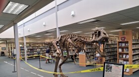 The Cortez Public Library will close its summer reading program July 31 with a paleontology talk, prize deadline and reminder that overdue items can be returned without fines.
 -
 One of Colorado's most productive peach farmers is preparing for the possibility that irrigation water may be turned off before the harvest is finished.
 -
 A substitute judge will be temporarily handling cases on the docket of Montezuma County Court Judge Ian MacLaren.
 -
The monsoon season is off to a promising but intense start in Montezuma County.
-
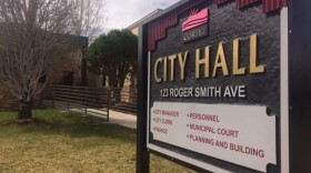
Montezuma County residents questioned commissioners about replacing millions in lost Kinder Morgan tax revenue during a community town hall in Dolores.
-
The Montezuma County commissioners continue to struggle with the issues of rubbish and blight. For some time they have said many county residents want unsightly properties to be addressed.
-
 Millions of Coloradans remain under strict water restrictions because of historic drought. Failing to conserve could mean empty reservoirs, and even harsher restrictions.
 -
 Cortez Municipal Court is launching a Teen Court program that will train young volunteers to serve as attorneys, jurors and judges in cases involving their peers.
 -
 This week’s Farm News & Views Report covers proposed Brazil tariffs, projected farm losses, specialty crop challenges, Farm Bureau policy priorities and CRP grazing proposals.
 -
 Tonight Mark and I lace up our boots and step into the haunted streets of Durango, so join us on The Dark Canyon Chronicles, as we walk beneath the glow of the streetlights, peaking into the old hotels, forgotten alleys, and the weathered brick buildings, where everything seems to have a story.


NPR News


An award-winning documentary that celebrates the rivers, wildlife, and communities that make the American Southwest one of the most extraordinary places on Earth. Tickets and more information are at sunflowertheatre.org

Historical stories from the Montezuma Heritage Museum's archives in the words of the people who lived them here in Southwest Colorado...read to you by local residents.

Check out upcoming events!
Stories from the RMCR network across the inter-mountain West!


Catch up with Bob Bragg on all things agricultural!
Catch up on all the news from Indian Country!