-
 How dry is it in the Four Corners? Statistics give the answer.
 -
 Showers and thunderstorms are expected across the Four Corners today, with gusty winds, small hail and isolated heavy rain possible before hotter, drier weather returns later this week.
 -
A spring storm is bringing widespread rain, cooler temperatures, mountain snow, and possible freezing overnight lows across the Four Corners region this week.
-
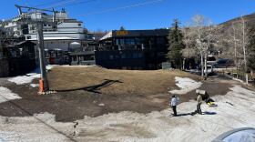
 After a record warm and dry winter, ranchers and farmers brace for a challenging summer.
 -
Today’s Outdoor Report tracks changing spring conditions across the Four Corners, with scattered storms, gusty winds, and a stronger system bringing mountain snow and possible travel impacts midweek.
-
Strong winds up to 55 mph are expected midweek across the Four Corners, followed by cooler, unsettled weather and mountain snow later this week.
-
 A new outlook warns of increased wildfire risk across Colorado and the West, driven by drought, low snowpack, and a warm, dry winter.
 -
Drought conditions in Cortez worsened after a warm, dry winter. Forecasters say drought is likely to persist across the West through spring.
-
 Extreme heat, expanding drought, rising fertilizer costs, and policy changes are shaping a difficult spring for farmers across the U.S., including the Four Corners region.
 -
 The unseasonal warmth that broke longstanding temperature records across the West last week was a hit to Colorado's already low snowpack. Climate change drove the heat wave, but scientists say it's still an outlier in today's world.

© 2025 KSJD

Ideas. Stories. Community.
Play Live Radio
Next Up:
0:00
0:00
Available On Air Stations


